![[Image of 5-day forecast and coastal areas under a warning or a watch]](http://www.nhc.noaa.gov/storm_graphics/AT01/refresh/AL0113W5_NL_sm2+gif/210513W5_NL_sm.gif)
Tropical storm Andrea made landfall as a strong Tropical storm at 65 mph winds in Dixie County Florida during the late afternoon hours, the winds have weakened which is expected with landfalling systems but surprisingly the pressure is still falling with this sytem

We are beginning to see the storm move NNE starting its run up the east coast, and interacting with an incoming cold front which is allowing tropical moisture to stream northward well ahead of the storm , and with that rain and breezy conditions are already overspreading despite the storm still being so far south
The rain will gradually increase in intensity as the night goes on and into tomorrow with increasingly windy conditions, the storm will peak out tomorrow afternoon into the evening hours
The storm has been lopsided with most of the activity on the east side, but as the storm becomes sub tropical the heaviest rain will shift to the west side of the storm

We see the storm is expected to track along the immediate coastline which will put most of the forecast area on the west side and thus the wettest side of the system
Flash flood watches have been issued for the forecast area by the National weather service for widespread 2-4 inches, locally more, I expect most of the area to be on the higher side of that (3-4 inches widespread with locally 5+) based on all the tropical moisture available and the model consensus of higher totals
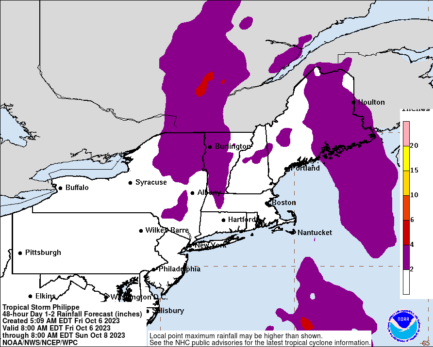
Above are expected rainfall totals for the storm , I would personally shift this whole swath west a bit based on full model consensus of a track that is farther west, this is based on the NHC track which is farthest south and east , but anyway clearly flooding will be a threat and the biggest threat with this storm, as the strongest winds should remain offshore , it will be breezy with perhaps some tropical storm force gusts in heavy rain bands but nothing severe or damaging is expected , of course rough seas and some minor coastal flooding will be possible as well. The best potential for any damaging winds will be along the southeast coast from coastal Georgia to coastal VA where they will be on the eastern flank of the storm and thus why tropical storm warnings have been issued for those areas
As this complex set up really gets going tonight a warm and humid tropical air mass will be transported into the forecast area and remain in place through the weekend with highs in the mid 70s to low 80s and lows in the mid to upper 60s , additional rainfall potentially heavy with showers and thunderstorms is expected Monday into Tuesday with another storm system, so clearly we will be on our toes over the next 5 days.
